Tampines

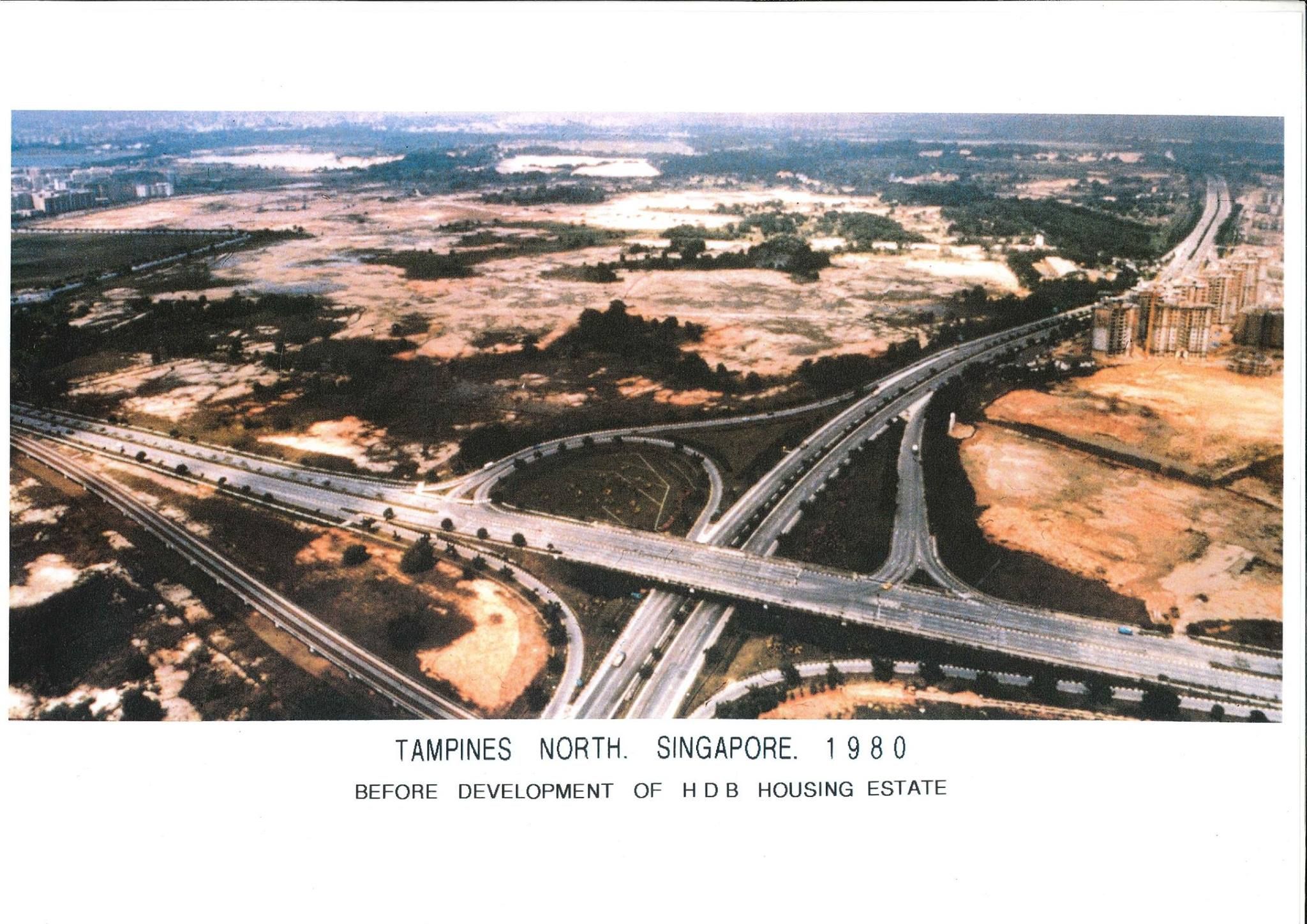
📷: Tampines in the 1980 before the development of HDB housing estates (Credits to: NHB)
Located in the eastern region of Singapore, it is hard to imagine Tampines’ former rural days as a farming and fishing village with plantations, when juxtaposed with the sheer number of people at Tampines today.
The earliest record of Tampines was believed to be found in the Tampenus River in Lieutenant Philip Jackson’s 1828 map of Singapore, and the river probably derived its name from the Tempinis tree that grew abundantly in the area then.
Tampines Road had formerly been a bridle path accommodating horse and pedestrians, which was later converted into a cart tract in the 1860s. The road, which extended towards Sungei Tampines (Tampines River), spanned from the 6th milestone of Serangoon Road (known as Kovan today) to Changi Road near the eastern tip of Singapore. Many early village dwellers settled along this road, and some of the villages here included Kampong Teban, Teck Hock Village, Hun Yeang Village and Kampong Tampines. It was a main access mostly used by coconut plantation workers, sand miners and travelling hawkers.
Many Tampines dwellers would remember the sand quarries that existed in Tampines, as Tampines was associated with the sand quarrying and waste disposal industry from the 1960s to the 1980s. Sand from Tampines was used for the building of Housing & Development Board (HDB) towns in the 1960s, and demand for the material was so high that at its peak, there were 26 sand quarries operating in Tampines.
Tampines is a notable town of many firsts. The construction of Tampines New Town began in 1979. Being the first new town developed based on a neighbourhood and precinct planning concept by the HDB, Tampines marked a new milestone in the evolution of HDB’s residential development typology.
The Tampines Central Park, which houses the well-loved watermelon and mangosteen playgrounds, is an example of the HDB’s introduction of integrated green spaces as part of its town planning innovations in the 1980s. Pioneered in Tampines, this concept was the precursor to the park connectors that are found all across Singapore today.
Besides that, Tampines is also Singapore’s first regional centre – a “mini city” containing offices, homes and recreational facilities, following a 1991 concept plan to grow commercial and retail centres in suburban areas.
Our Tampines Hub too, was Singapore’s first integrated community and lifestyle hub. It was constructed based on public consultation involving more than 15,000 Tampines residents. The 5.3-hectare multi-purpose complex houses various amenities, including retail shops, a hawker centre, a regional library, spaces for community events, and sports facilities such as badminton courts, amongst others.
It was highly unlikely that anyone living here in the 1980s could imagine that Tampines would receive the United Nations’ World Habitat Award in 1992, beating out contending entries from cities such as Vancouver and Boston. The award recognises innovative and successful human settlements, and marked a significant achievement in Singapore’s public housing. Overnight, Tampines New Town became recognised as an exemplar of “high-quality, high-density and affordable housing”, and was touted as a model that cities around the world could replicate.
Today, Tampines stands as a prime example of the importance of thoughtful urban planning. As Tampines continues to evolve, the heart of its development remains rooted in fostering a strong sense of community and neighbourliness among its residents.
Interested to learn more about everyday heritage that are part and parcel of the Tampines community? Explore Tampines New Town here (https://search.nlb.gov.sg/.../storymaps/tampines/index.html) and check out the Tampines Heritage Trial here (https://www.roots.gov.sg/.../Tampines-Heritage-Trail...).

